Every day, millions of people find themselves thousands of miles from home. Some people travel for business while others go for leisure. Yet, a frequent lapse made by the majority of travelers lie in the lack of preparations, should a national emergency strike.
Undoubtedly, every household should have a “Get Home Plan” in place in the case of a local or broad disaster. You should have a variety of strategies in place, including communications, getting home, bugging out, purchasing supplies and rotating them, and so on.
Civil unrest can pose some difficulties, but nothing that a solid strategy couldn’t address. We’ll look at a getting home strategy in the context of civil disturbance in this article:
- Crafting an escape plan
- Open Source Intelligence
- Human Intelligence
- Signals Intelligence
- Imagery Intelligence
- Geospatial Intelligence
- Preparing Caches
Crafting an Escape Plan
Nowadays, you can never be too ready. Having a strategy to get out of a dangerous situation might save your life.
Preparing a basic survival kit, a rendezvous point for you and your family and friends, and the appropriate bug out routes depending on where you are when the event occurs, may increase your chances of survival when SHTF.
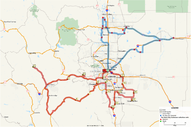
Different routes, possible risks such as violence and drug operations, established safe locations, resources such as gas stations, groceries and fast food, fire and police stations, hospitals, types of roads such as asphalt or dirt, and so on are all things to consider while choosing your route home.
Here are a variety of sources from which we might gather information.
Open Source Intelligence (OSINT)
Keywords like “gangs” can be searched on Google and Bing, among other search engines. One may certainly obtain city maps that show which gangs operate or “claim” particular neighborhoods.
You may also discover images of numerous gang signs to include to your intelligence package and keep an eye out for in your area.
Here are some things that you can do with OSINT:
- Google Alerts (google.com/alerts) can send you email updates based on what you ask it to look for, such as gang news or power shortages, among other things.
- Demographics, locations for police and fire stations, and other public facilities may all be found on the local municipal website. Your local emergency management agency’s website may provide details about CERT teams and other initiatives.
Human Intelligence (HUMINT)
Go around several neighborhoods or routes that you could take to get home and record the area you’re driving through with a dash camera. The routes may then be reviewed, and you’ll be able to spot items you might not have observed while driving. Using a dash camera is far less inconspicuous and dangerous than recording with your phone while driving.
By watching who is around in grocery shops and gas stations, you may obtain an understanding of who lives in the neighborhood. Drive through at various hours of the day and night, preferably late at night.
Signals Intelligence (SIGINT)
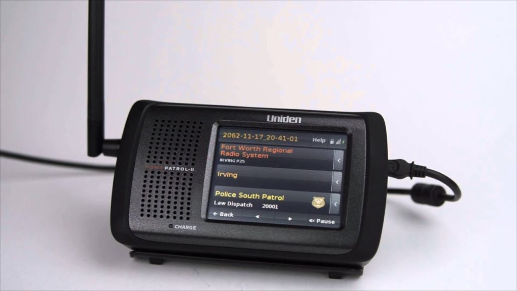
It is strongly recommended that you get a scanner, such as the trunk-capable Home Patrol 2. This will provide you with access to information such as what local law enforcement is responding to, most of which is not reported in the newspapers or even on the police website. Most importantly, you’ll be able to hear it in real time.
It’s critical to spend time listening before SHTF so you can understand their language, such as codes, districts, and so on.
One may also use radio reference websites to locate utility company frequencies, such as electricity, which might offer you information if and when the power goes out. The frequencies of news organizations will also be listed; you may hear pre-air discussion between reporters in the field and the studio, as well as their studio deploying them to situations.
TLDR; Carrying a portable scanner allows you to stay alert amid civil disturbance and make necessary route adjustments.
Imagery Intelligence (IMINT)
Maps are generally available at truck stops and bigger gas stations along interstates. The huge book maps for your state are typically available, and you may pull highlighted pages out as required.
Make a series of routes on paper maps. Outline the different paths with colored pencils, but first make sure you can see them under a red night (saves your night vision). You’ll probably discover that red hues aren’t visible, so try something else. If you’re using a map that’s printed on both sides, be aware that highlighters might bleed through.
For convenience, here are some examples of online map resources:
- USGS.gov and www.mytopo.com for topographical maps
- Imagery maps from Google Earth
- Street maps from Google maps, Garmin OpenStreetMap and other sources
- Garmin Basemap (software for their GPS units)
You may use Garmin’s Basemap software to generate routes and markers for your GPS. You may store alternate routes on your device once you’ve created them, presumably using some type of color or other code reference.
You may also build resources and threats using the photos of the region. Color coding can be used to represent the threat level. For example,
- Red – danger, such as gang territories.
- Yellow – Moderate regions, petrol stations, stores, and other resources are highlighted. You might still have to exercise tremendous caution since the situation might alter at any time.
- Green – Advocates of the rule of law who may be ready to assist. This might include welcoming communities.
- Blue – Patriots, family members, friends, or anyone who are willing to help.
Geospatial Intelligence (GEOINT)
Geospatial intelligence is information about anthropogenic activities on the planet generated from the study and use of images.
Using Google Earth, for example, can give some excellent photos of structures, railings, road types, alleyways, and the like. When paired with data from other mapping tools, you may create a detailed map of the routes, topography, and other hazards.
Look at alternative paths for walking versus driving when developing your maps and routes. Think about whether you should walk the trip during the day or at night. You may also have to include routes that stop at areas where family members may be picked up, such as your partner’s workplace or the schools where your children go.
You may convey your routes to other family members by color-coding or otherwise labeling them. It’s a good idea to give your routes names that you might use in regular conversations.
Preparing Caches
Depending on the distance you’ll have to go and your routes, you should consider stockpiling extra provisions. Unless you have friends or relatives along the road, this may not be practical in urban locations. If you pass through rural regions, it could be a little simpler. Make sure you keep a record of where you’ve put caches, both on paper and with a GPS unit.
Meals, such as protein or granola bars, emergency ration food bars, dried food, and so on, are examples of cache goods. If you’re using cans or mylar pouches, water could be a possibility. MRE beverage powders may even be added, however MRE food should not be stored. You might want to include batteries for your ham radio and/or flashlights. A spare ham radio that has already been programmed might also be handy.
Final Thoughts
There are several crises that can occur at any moment and in any location. Although the chances of being stranded away from home in an emergency are slim, it is possible. You may protect yourself against this by devising an emergency escape plan and other travel routes with some forethought and planning.
Alternative travel routes might assist you in getting back to your residence more swiftly and efficiently. Sharing this strategy with your family and friends can help you reunite everyone in the comfort of their own homes.
Although you may never need to adopt survival escape routes, the world is in such disarray that someone will, and you never know when it will be you.