Conventional land navigation is a perishable skill that must be practiced like so many other survival skills. I would argue that Land Nav is the most difficult skill to learn and a major challenge to master. There are several fine books on the topic but what if you have no interest in taking up the hobby of orienteering? You might only be interested in finding your way home in the wake of an emergency. Perhaps you were out hunting and became disoriented in the woods after tracking that blood trail, or something even more serious has happened. There are a few scenarios where finding the way home moves to the top of your list of priorities for that day.

Survival navigation is the down and dirty version. It utilizes components of the entire spectrum of orienteering. Unlike with the hobby you may suddenly find yourself inserted somewhere without a plan, without equipment, and possibly injured. A well-planned hike should always include the proper equipment, knowledge of the weather and terrain, and filing of a hike plan. Also, you should notify someone of that plan and when to expect your return just in case of emergency. A survival situation can happen at any time. You may have let someone know of your daily plans, but a no-notice disaster such as an EMP could prevent them from doing anything to help you. You could very easily find yourself on your own.
First Things First
The ability to collect your thoughts, gain composure, and focus on the task at hand could prove vital to survival. We all know it’s a great idea to keep equipment such as EDC kits, Get Home Bags, and vehicle kits with us. Hand’s down, skills are always your best investment. Murphy’s Law of Survival states that the best skilled and equipped survivor in your group will have perished in the crash with their gear burned up. In short, you are your best chance of survival. Will you be ready for the challenge?
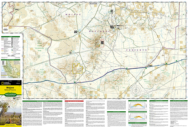
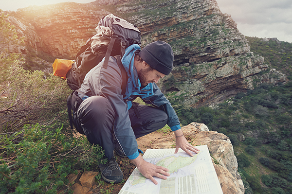
There are several items you can carry to improve your situation. A good map of any area that you may need to travel through is one of them. There are several types and styles of map available. If you’re well versed in navigation, a topographic map will be an invaluable tool. A topo map provides an overhead graphic representation of the terrain that a typical road map won’t provide. This is necessary in case you need to leave the road and head cross-country.
The knowledge of terrain obstacles that may lay between you and your destination will save considerable time and energy. I recommend a USGS map in the scale of 1:24,000. This will offer you a decent compromise in distance and terrain detail. It’s also a common scale and map type used by the military and long-distance hikers. Each grid square is a 1,000 meter box which lines up with kilometers and easily works with the next recommended item. USGS maps can also be printed on weatherproof paper if you order them online. There’s also the option to download them from the USGS.gov website in PDF format at no cost and have them printed at a local office store.
Ranger beads are a simple item with 15 beads strung snuggly on a short length of cord. The cord is often made from 550 parachute cord arranged in a loop with 5 beads above a knot and 10 more beads below. The idea is to slide one bead for every 100 meters you walk. After sliding all ten beads, reset them and slide one of the 5 beads down which indicates you walked 1 kilometer. Before you utilize this method of simple pace count, calibrate yourself by marking out a one hundred meter course on the ground. Walk it several times and count only when the left foot hits the ground. Use a solid pace count to know how far you’ve travelled. You can also do this for uneven terrain and for a running pace. Everyone should know their pace count.
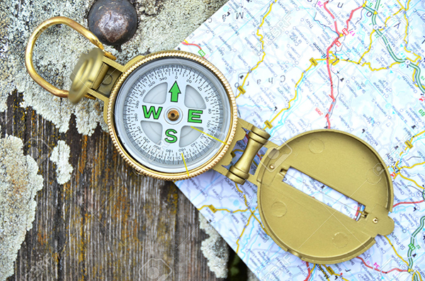
A good compass can be a lifesaver. It may not always be practical to have a fancy compass with you, but should always have a simple direction indicating compass. The need to identify the direction of travel is critical in survival. Cheap bubble compasses that cost less than a dollar have saved lives because they kept the survivor from walking in circles. You may not be able to cast a solid navigational bearing with one but going in a straight line saves time and energy. This is important when trying to outrun the sunset, dehydration, and calorie loss.
If you’re planning to use a topo map, it would be wise to also have a map protractor. This is a thin plastic item that is designed to work with the map. It translates the bearings from map to compass, and vice versa. It also easily identifies the distance within the map grid squares. A good protractor is cheap and worth its weight in gold.
An old fashioned analog watch is also a great aid to navigation. You can use it in lieu of a compass, time your travel, and effectively use it to determine how far you had to divert off-course to avoid an obstacle. By keeping time in a diversion, you can use that amount of time to get back on course on the far side of the obstacle.
It should go without saying, but you must attempt to provide for your physiological needs in case you find yourself trying to walk home. Keep a good walking outfit and shoes along with appropriate climate gear with your GHB if possible. Don’t forget to change the gear for the seasons or travel destination.
When planning to hoof it home, build on the physiological requirements of survival before you get too far down the road. Most Land Nav is designed to get you from point A to B. In reality there could be other interfering factors such as dehydration, hostile territory, hostile terrain, hostile climate, travel restrictions, containment/quarantine, damaged infrastructure, etc. It would be wise to gather as much raw intel from the community around you as possible and convert it to usable information.
Your individual fitness and that of anyone in your traveling party will have a direct impact on the estimated time of arrival and ability to complete the journey. Too often I have had people share their bug out plan to walk to the hills some hundreds of miles away and expect to cover 20 miles a day, 7 days a week. To make matters worse, they plan to do this with a toddler and maybe grandma. Take into consideration the ability of those who are with you. Be realistic in your planning and make every effort to simplify an extreme journey by having or acquiring useful equipment such as a quality off-road baby stroller, wagon, bicycle, wheelchair, etc. to carry people and gear.
A fit adult can walk between 2.4-4 miles per hour and cover twenty or thirty miles in a day but not every day for the long term. Especially if an injury happens or there is a shortage of water and food.
When route planning it will be necessary to identify sources of replenishment such as water and food. Those are consumables and can be heavy, so it makes sense to think ahead so you don’t come up short. A map that covers the entire route will allow you to mark those areas of concern and either go there or skirt them. Keep in mind that heading into the brush and hoofing it cross-country may be shorter but possibly more hazardous if you trespass on private property. Selecting a route and following it is only part of the equation. You must stay aware and avoid trouble during the journey whether it’s across town or from hundreds of miles away.
A good starting point in your route planning is to lay out the map(s) and visualize a straight line to the destination. Now look along that route for resource availability. Mark those opportunities on the map. Next, try to identify any areas you think should be avoided. The first thing that always comes to mind has to do with bad people in those areas. That’s ok but also think about physical terrain that should be avoided. If the terrain isn’t passable such as cliffs, gorges, large water features, or swamps, make the note on the map to try to avoid them if you’re not prepared to negotiate them.
I would also look at tactical considerations such as chokepoints, bridges, or junctions where a checkpoint might be established. Main town entry routes, critical infrastructure locations, or other main avenues of approach should be treated as hostile until proven otherwise. There’s a rule in recon that is to never take the easy route, they’ll be expecting you. No one ever received a medal for winning a war ahead of schedule or under budget. Take your time and go where others can’t or won’t.
Once your map is marked with go and no-go areas then you can connect the dots to create the route. If you want to get an idea of how far and how long the journey should take, lay out a string or a small piece of wire on the route. Measure the distance by comparing the length of string to the map legend. With a general distance in mind you can calculate the speed of travel, expected number of hours per day of travel, and come up with a total. I would recommend you add at least a third of the time, if not more, for a realistic duration. This doesn’t include laying up for any injuries or other delays. A 600 mile trip may come up to about 3 weeks but in reality it could take 6-9 weeks.
Another consideration is the climate. If you find the need to make a foot journey across the Rockies in the fall or winter, you don’t want to become known as the next Donner Party. You may want to wait for the spring thaw. That could add months to your journey.

Once you’re underway, utilize your skills to keep moving in the right direction. We know that not everyone is a master navigator but there are a few pointers that anyone can use, even children. Understand that the sun rises in the east and sets in the west. During the winter the sun is lower in the southern sky. If it’s visible, the moon will follow the same trajectory from east to west. Make it a practice to look at the moon and notice the terrain and/or shape. It will be consistent through the night. The points of a crescent moon generally line up to point downward and south. When walking during the day or night, keep the sun or moon in mind to help you not go in circles. For example, you may be able to keep them over one shoulder once you know which way to travel.
Another tip to remember is that most people have a tendency to keep drifting in a certain direction. This causes them to unknowingly walk in circles. It’s not uncommon to walk in a circle only to find your own footprints and follow them. You must ruthlessly trust your compass. Use a simple tactic called dead reckoning. Yes, it sounds like a scary movie. In reality, it means to look to the next prominent terrain feature and walk to it rather than staring at your compass the entire time. You’re more likely to stay on course over lengthy distances with a focal point to watch. Once you get there, shoot another compass bearing to another prominent feature and walk there. Of course, this doesn’t work quite as well when you are in the thick of the woods. You have to keep mixing up your skills along the way. Avoid animal trails and paths that can lead you astray. These are called natural lines of drift and may go somewhere you don’t want to go.
Be flexible and work to solve the problem. Out of control emotions will derail your efforts. If you need to sit down and collect your thoughts, do that. Land navigation in a threat environment takes laser focus and a preparedness to react instantly.

The takeaways for survival navigation are to prepare as needed for any trips based on the current or expected threat level. Equip yourself properly with gear, navigation materials and skills, and make a plan before you start walking. On the trail, know your surroundings, gather intel continuously, and adjust the plan as needed. There were several items and concepts written about that should be learned to use the information successfully. Take some time to read up on them. Most importantly, go outside and try these skills out. Land navigation is a most humbling skill that crushes the best navigators. Focus on a few basics and build on them to give yourself a fighting chance for survival.
Get lost if you want to, know how to stay found in case you need to.