I love spending time in the woods but getting lost is always a risk. It can be easy to get turned around even when following clearly marked trails. Every year thousands of hikers and campers get lost in the woods, some of them never make it out alive. The scary part is that most of these people are within a mile of their trail. Even wandering a few dozen yards in the wrong direction can mean disaster in a dense forest. The key to ensuring that this doesn’t happen to you is having solid map reading skills.
Unfortunately, reading a map is becoming a lost skill. These days most people rely on GPS on their phones to get where they need to go. The ability to use a compass and map reading to navigate has almost disappeared. I worked for a company 10 years ago that required us to route out 30 stops per day and then visit those properties. I was one of the only people that used a map while everybody else relied on GPS. We all worked at about the same pace under normal circumstances but when their GPS battery died or lost reception they were done for the day. I quickly appreciated my old paper map. So, let’s cover how to use a map and compass when navigating the wilderness.
Using a Map and Compass Together
Combining a map and compass is the most accurate way to navigate in the wilderness. This is because there is absolutely no need for landmarks if you know your cardinal directions and have a map.
If you’re lost in the woods, first find a flat area for your map. Unfold the map and spread it out on the flat area. You’ll notice a legend in the corner that has the four cardinal directions labeled. In almost every case North and South will be the top and bottom of the map. East and West being the right and left sides.
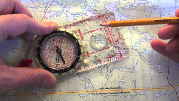
Get out your compass next. Make sure it’s oriented so that North is at the top of the dial. Set the compass down on the map next to the legend. Keep in mind that it’s vital the map be on a flat surface parallel to the ground. You’ll see the compass spin a bit until finally it will settle on a particular direction. Next rotate the compass so that due North is lined up with the red arrow. Now you have your cardinal directions. Spin the map underneath the compass so that North on the map legend lines up with North on the compass. Your map is now oriented, and you can review where you might be.
Reading Your Map
Finally, you can start to plan your route of travel. Look for the closest trail, landmark, road, or body of water and note the cardinal direction in which you need to travel. As you travel, keep the compass out to regularly check your direction. Stick to this direction and you should be able to reach your destination.
 In addition to using the cardinal directions on the legend, you should be familiar with the other tools it provides. The legend will show you different markings for water, trails, gravel roads, paved roads, campsites, parking lots, private property, national forest land, bathrooms, ranger stations, and historical sites. One of the most valuable parts of the legend is the scale indicator. This will show you what length on the map equals a particular distance on land. For example, one inch on the map might equal one mile on land. This can tell you how far to travel to reach your destination. Then you can use time to estimate your arrival. For example, on moderate off trail terrain I travel around 3 miles per hour. If I have to travel six miles, it should take me about two hours without any breaks.
Compass Use Only
While it’s ideal to have both a map and a compass, you can still get benefit out of just having a compass. As a general rule, I note what cardinal direction in which I am travelling when starting a hike. On my last camping trip, I travelled due North from the parking lot as I approached a river. If you note this in advance, it can likely help find your way home.
When you become disoriented, simply pull out your compass and place it on a flat spot with the dial showing North at the top. Once the needle stops you will rotate the compass to line up North with the red needle. This will show you which direction is South. Travel back in that direction and you should be fairly close to your departure location. Just take it slow and look for familiar land features. Being off by just a few degrees over several miles can cause you to miss a specific spot like a parking lot. You’re better off to shoot for a linear feature like a road, trail, creek, river, or lakeshore. That way it’s almost impossible for you to miss your target.
Map Reading Only
Navigating the wilderness with a map and no compass is probably the most difficult of these options. You have to have a way to orient the map or it’s worthless. However, there are ways to do this without a compass. The easiest way is to find a high spot like a bluff, hilltop, or treetop. Look for landmarks from there. These include rock formations, bodies of water, roads, or buildings. Using these landmarks and their location, you may be able to orient the map to figure out your location and destination.
Alternatively, use your environment to determine approximate cardinal directions. You can build a sun compass, watch compass, or water compass, or you can look for consistent moss growth on one side of a tree to find North. If you find a tree out in the open by itself and the branches are primarily growing on one side, that side is likely facing South. Finally, you can just rely on the fact that the sun rises in the East and sets in the West to help you get roughly oriented.
 Final Thoughts
When spending time in the wilderness, there aren’t many tools as valuable as a good map and compass. However, they’re worthless if you don’t know how to use them. Last year I was hiking in one of my favorite parks and ran across a group of teenagers on an orienteering course. Unfortunately, all of them were using digital GPS to find their checkpoints. GPS isn’t always reliable, so don’t rely upon it. Take the time to practice reading a map and compass. Be sure to pass the skill on to the next generation. There will never be a replacement for these vital tools.
