


SDN has moved!
Subscribe to our new @SurvivalDispatchNews YouTube channel
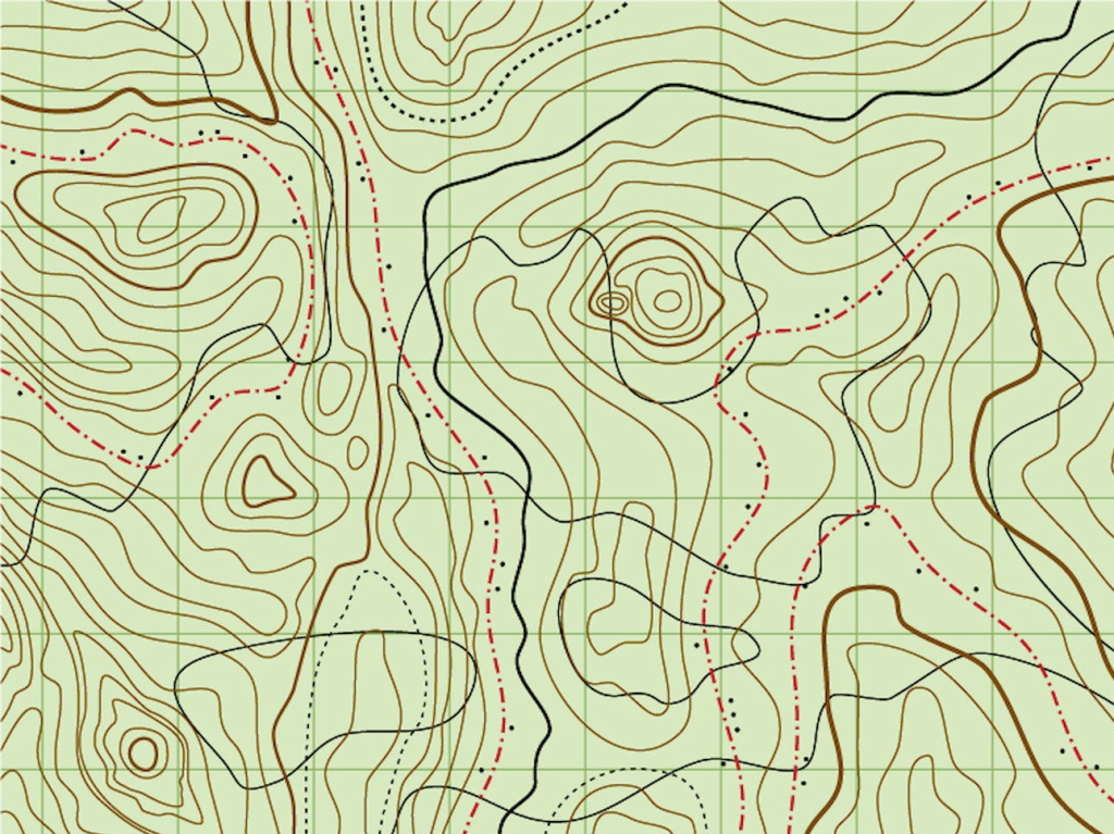

Map Features for Land Navigation
– A Declination Diagram (relationship between grid & magnetic north)
– Scale (fraction of ratio of a map to corresponding distance on the surface)
– Bar Scales (rulers used to convert map to ground distance)
Terrain Features for Land Navigation
Major
– Hill (high ground, slopes on all sides)
– Saddle (area between 2 hills, ground slopes up on 2 sides & down on 2 sides)
– Valley (low ground between 2 ridgelines)
– Ridge (elongated, sloping high-ground, contours form V or U that points down)
– Depression (low point w/ steep walls)
Minor
– Draw (low ground between spurs)
– Spur (smaller ridge, extending off of a large ridge)
Supplementary
– Cliff (near vertical drop, cliff convergence)
– Cuts and Fills (man-made cut in high-ground, or fill in low-ground)
Map Reading
To find the grid location on the map, first find the closest easting line to the west of your target location. Then, find the closest northing line to the south of your target location. This will give you your 4 digit finding. Each further step (additional digit) increases proximity by narrowing down using 2 more digits at a time. Go right and up from the southwest corner of the four digit grid location in 100m increments. Go right and up from the six digit location in 10m increments.
Traveling
Use protractor/compass, determine azimuth, rotate bezel to align w/ index mark.
Maintain bearing in direction of travel by sighting a reference point (tree, tower), travel towards visual landmark, repeat.
Pace
Find Your Pace
Count the # of times the same foot strikes the ground on a straight known distance line of 100 feet (or adapt to unit of measurement related to your map/course).
Example:
Normal Terrain 60 per 100 meters
Rough Terrain 75 per 100 meters
Easting then Northing or Read Right then Up (Map Reading) | East is Least, West is Best (Declination)
1 FT = .305 M | 1 YD = .914 M | 100 M = 109.3 YD | 100 YD = 91.4 M | 1 MI = 1.61 KM | 1 KM = .621 MI | 1 KM = 1000 M | 1 MI = 5280 FT
This article was originally written by the Grayman Briefing. Stay in the know. Sign up for Intel and Situational Awareness alerts pushed to your phone on emerging threats and preparedness warnings. Click HERE to subscribe to the Grayman Briefing.
=====
Become a Survival Dispatch Insider …
We bring together survival enthusiasts and preppers to share skills and knowledge, so you can enhance your preparedness for emergencies and ensure the safety of you and your community.
The Results You’ll Get …
Our community, courses, and memberships are pretty special. We focus on the ways it will make a huge difference in your life.
Here are a few of the things you’ll be able to do as a member of Survival Dispatch Insider …
1) Improve your emergency preparedness by learning survival skills and strategies from experienced preppers.
2) Build lasting connections with like-minded individuals that share your passion for safety and readiness.
3) Access a wealth of knowledge and resources to assist in protecting you and your community during unexpected situations.
Click HERE to get started.
=====